


LandGlide: Land & Parcel Data
4.32.59K Reviews
App Specs
- Version
- 5.6.0
- Updated On
- License
- Free
- Downloads
- 1,000,000+
- Developer
- Real Estate Portal USA
- Categories
- Maps & Navigation
- Platform
- Android, iOS
Screenshots

 Analysis by AppCompare
I find LandGlide most useful when a standard navigation app answers “Where am I?” but not “Which parcel is this?” Its focus on property boundaries and parcel details gives it a distinct job within Maps & Navigation. That makes it handy for exploring land, checking a location before a visit, or getting a quick lead on ownership, but it is not a replacement for an official survey or a dependable turn-by-turn navigation tool.
A map built around parcels, not just roads
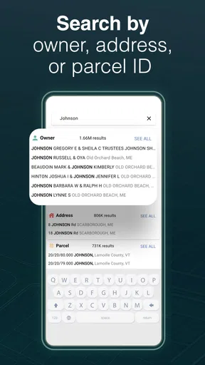
The practical difference is the way LandGlide shifts your attention from streets and destinations to the land between them. You can use GPS while looking at a map, or search by an owner, address, or parcel. Those options suit different starting points: GPS helps when you are already near a property, while an address or parcel search is more useful when you are planning from home. Searching by owner can help narrow down a property when you have a name but not a precise street location.
That flexibility makes the app useful before and during a visit. I would search an address ahead of time, then use the map while approaching the area to orient myself. If I were already out walking or driving, I would use GPS to see which parcel I was near, then treat the displayed boundary as a reference rather than a line to follow on the ground. Parcel maps are a starting point for understanding a place, not proof of a legal boundary.
When parcel context is more useful than directions
A conventional map is better when I need traffic-aware routing, a clear route to a business, or help finding a public entrance. LandGlide makes more sense when the question is about land ownership or parcel context. The two kinds of apps can complement each other: I would use a regular navigation app to get to a road or trailhead, then open LandGlide to inspect nearby parcels. That division of labor is more sensible than expecting one map to do both jobs equally well.
Consider a realistic weekend situation: I spot a vacant-looking lot while visiting a neighborhood and wonder whether it is a separate parcel or part of a larger property. I can check the map, compare the parcel outline with nearby addresses, and save the location to revisit later. That is a useful way to organize curiosity or preliminary research, but it does not settle questions about access, ownership rights, or whether a property is for sale. Those require independent confirmation.
What the app is—and is not—good for
LandGlide is a stronger fit for people who repeatedly need a quick parcel reference: real estate researchers, landowners, outdoor enthusiasts, and anyone comparing locations before making calls or visits. It can also help a homeowner make sense of the parcels around their street. The app is less compelling if you only need occasional directions, or if your decision depends on exact boundary placement. For that, a qualified surveyor and official records are the better route.
One useful habit is to save a property when you find it, rather than relying on memory after moving around the map. That turns a casual browse into a small research list: you can return to places you want to compare or investigate. I would also note the address or parcel details that matter to my question, then verify them through the appropriate public office before making a financial or legal decision. The app can help me find the right lead; it should not be the final authority.
Worth Reading Before You Choose

EA SPORTS FC Mobile 26 Is a Bigger Football Game, but It Takes Time

Flipboard Shows What News Apps Must Do Beyond the Feed

Switching to Android Auto Means Rethinking Your Driving Routine

Google Calendar Makes a Crowded Week Easier to Manage

Ludo King Makes the Most of the Minutes Between Plans

Baby Panda World Brings Quick Play to Modern Phones, but Its Game Library Feels Busy
Access, cost, and expectations
LandGlide is a free app from Real Estate Portal USA, with in-app purchases listed from $9.99 to $99.99 per item. It has a 4.3 average from around 8,700 ratings, and more than a million installs. That suggests it has found an audience, but popularity is not a guarantee that a particular parcel record will answer every question. I would try it for the specific task I have in mind and check the purchase options in the app before relying on extended use.
The app is rated for Everyone and runs on Android 8.0 or later; version 5.4.4 is the current version. It was released on May 9, 2016, so it is an established product rather than a brand-new mapping experiment. Still, map data and parcel records can vary in usefulness from one location to another. If you are considering it for work, test the places you actually deal with instead of assuming that a good experience in one area guarantees the same results elsewhere.
Offline access is a question worth thinking through before heading somewhere remote. The published article describes an offline mode as part of a subscription, but I would not plan a trip around it without checking the current in-app terms and testing the workflow beforehand. In any case, a downloaded or cached map does not turn parcel lines into survey-grade measurements. For fieldwork, I would bring the tools and documentation appropriate to the job rather than treating a phone display as a substitute.
There is also a privacy and etiquette angle to using ownership information. Looking up a parcel can satisfy ordinary curiosity or help with research, but it does not make a private property public or grant permission to enter. I would use the app from a public road or lawful access point, and keep any follow-up respectful. That small distinction matters most when a map makes a boundary look easy to cross.
Getting Started with LandGlide
When I first downloaded LandGlide, I was a bit skeptical. I mean, an app that shows property lines and owner info? Sounds a bit too good to be true, right? But as soon as I opened it, I was greeted with a sleek and user-friendly interface. I’m not a tech wizard by any means, but navigating through the options was simple, and I was ready to explore in no time.
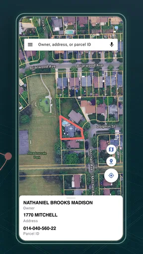
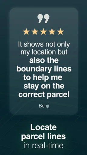
Setting up the app was a breeze. After a quick sign-up, I was ready to dive into a world of property maps. The app uses GPS to pinpoint your location and overlay property boundaries right on your screen. It was as if Google Maps had a secret property layer all along!
Exploring with Ease
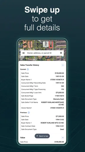
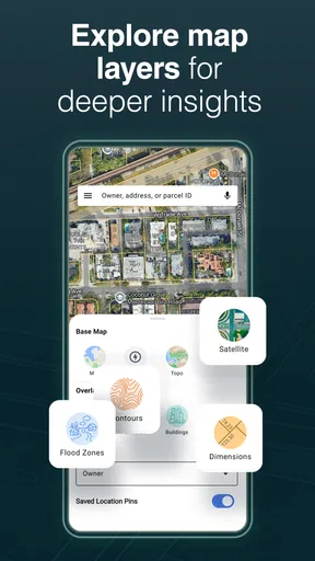
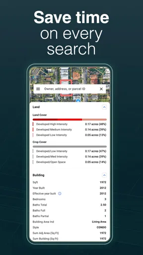
Once I started exploring, I realized just how powerful this tool is. The app provides detailed information about properties, including the owner’s name, total area, and even the assessed value. What’s even cooler is that it works both in the city and out in the countryside. Whether you're at home or out on a hike, you can find out who owns what land around you.
One of my favorite features has to be the ability to save specific properties. If you’re like me and have a slight obsession with keeping tabs on your neighborhood, this is gold. You can bookmark properties and come back to them later, which is perfect for anyone in real estate or just plain curious.
Accuracy and Reliability
Now, I know you’re probably wondering about the accuracy of this thing. Well, in my experience, it’s pretty spot on. The app updates regularly, pulling information from trusted sources. I double-checked a few properties around town, and the details matched up perfectly with what I found in public records. Of course, no app is perfect, and it’s always a good idea to verify important information, but I was impressed with how reliable it was.
In practice, I would separate two questions that can look identical on a screen: whether the record identifies the right parcel, and whether the drawn line is precise enough for a real-world decision. A match on an address or owner can be a helpful clue, but a fence, driveway, or visible marker may not follow the mapped outline. I would compare nearby parcels and addresses before drawing conclusions, especially where lots are narrow or irregular. That quick cross-check is more useful than zooming in and assuming a sharper display means greater legal accuracy.
Subscription and Features
Here’s the deal – LandGlide offers a free trial for seven days. After that, it’s a subscription model. At first, I wasn’t thrilled about this, but considering the depth of information and ease of use, it’s worth it if you’re frequently on the go and need access to property data. The subscription unlocks additional features, such as offline mode, which is a lifesaver when you’re in an area with spotty service.
Because the app is free to install but offers paid in-app items, I would distinguish trying it from committing to regular use. A casual user may only need to inspect a few locations, while a property professional might get more value from repeated field checks. Before starting any trial or purchase, I would read the current renewal and cancellation terms shown in the app and set a reminder if I only want to test it. That is a simple way to avoid paying for something I no longer need.
Offline use is especially easy to misunderstand. If I were going somewhere with weak reception, I would test the relevant area and the exact information I need while I still had a connection. I would not assume that every detail will be available simply because an offline option exists; preparation is safer than discovering a limitation after arriving. For a one-off rural visit, I would also keep the address and any essential notes somewhere accessible outside the map.
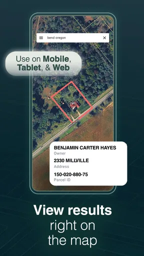
The app also supports multiple devices, so you can switch from your phone to your tablet seamlessly. I found this particularly handy when planning a road trip and needing to check property data on a bigger screen.
A larger screen changes the task in a useful way: it is easier to compare a cluster of parcels and keep several locations in view while planning. On the phone, I find GPS more convenient for checking one nearby spot; on a tablet, I would do the slower desk work of reviewing an area and saving candidates. I would still confirm that saved places are available where I expect them before depending on a device switch during a trip.
Who Can Benefit from LandGlide?
Honestly, LandGlide is a fantastic tool for a wide range of users. Real estate professionals, land surveyors, and even curious homeowners will find this app invaluable. It’s like having a personal property database at your fingertips.
For professionals, I see the greatest value in early-stage screening: checking a parcel before arranging a visit, identifying nearby ownership records, or making a list of questions for a later conversation. It can reduce guesswork during that first pass, but it should not replace the documents, measurements, or professional judgment a transaction or survey requires. The more consequential the decision, the more important that distinction becomes.
For a homeowner, a practical use might be checking whether a side strip appears to belong with a neighboring lot before contacting a local office. I would use the result to ask a better question, not to settle a disagreement with a neighbor. For someone who enjoys hiking, the app can add context to the landscape, but it should never be used to infer that a trail crosses private land with permission. A map helps identify parcels; it does not determine access rights.
For a newcomer comparing neighborhoods, I would use it as one layer of research alongside ordinary maps and local records. A parcel view may help distinguish a standalone lot from a larger tract, while a standard navigation app remains better for judging routes, drive times, and nearby services. If your main goal is finding homes currently for sale, a real-estate search app is likely a better first choice; LandGlide is about parcel context, not a substitute for a listing search.
For people who only want to know who owns one property once, the paid options may feel like more commitment than the task deserves. I would first check whether public records or a local assessor’s resources answer the question. LandGlide earns its place when the map-based workflow saves repeated effort, not merely because it can display information that may be available elsewhere.
For an everyday example, imagine I am driving through an unfamiliar area and notice a broad empty parcel beside a road. I would pull over somewhere safe, check the location in LandGlide, and save the parcel if I wanted to investigate it later. Back at home, I could compare the saved location with an address search and then use official records to verify any detail that affects a purchase or a conversation with the owner. That is a realistic, low-risk workflow: the app helps me move from curiosity to a focused next step without pretending to complete the research for me.
It is also worth deciding what “useful” means before opening the map. If I am trying to locate a boundary marker on the ground, the app may orient me but cannot tell me where to dig or build. If I am trying to identify a parcel to research, it can be much more helpful. That distinction keeps the app in its strongest role and prevents a convenient visual reference from being mistaken for a professional measurement.
Final Thoughts
In a nutshell, LandGlide is an impressive app that delivers exactly what it promises. It’s intuitive, packed with useful features, and provides accurate property details that are essential for anyone needing this kind of information on the go.
Whether you’re a professional or just someone with a keen interest in land ownership, this app is definitely worth checking out. Just be prepared to get a little addicted – I certainly did!
My bottom line is that LandGlide is a focused companion for parcel discovery, not an all-purpose map and not a legal authority. Its GPS view, owner and location searches, and saved properties make it easiest to recommend to people who check land information more than once. If your needs are occasional, start cautiously and compare the cost with free public-record options; if your needs are consequential, use the app to guide your research and confirm the result through official channels. For that specific middle ground between casual map browsing and formal property work, I think it earns a place on the phone.
Pros
- Intuitive interface for easy navigation.
- Offline mode for areas with no signal.
- Comprehensive property data coverage.
- Regular updates with new features.
- User-friendly search filters.
Cons
- Subscription required for full access.
- Limited free trial period.
- Occasional map loading delays.
- Some rural areas lack detailed data.
- High battery consumption during use.
FAQs for LandGlide: Land & Parcel Data
What is LandGlide and how does it work?
LandGlide is a GPS-based property finder app that allows users to access detailed property information, including boundary lines and ownership details. By using your device's GPS, it overlays property data on a map, helping users identify land parcels and their respective details. This is particularly useful for real estate professionals, surveyors, and land enthusiasts.
Is LandGlide available for both Android and iOS devices?
Yes, LandGlide is available for download on both Android and iOS platforms. You can find it on the Google Play Store for Android devices and the Apple App Store for iOS devices. Make sure your device meets the app’s system requirements for optimal performance.
Does LandGlide require an internet connection to function?
LandGlide primarily requires an internet connection to download property data and map overlays. However, once the data is downloaded, it can be accessed offline. This is particularly beneficial for users in remote areas with limited connectivity, allowing them to view property details without a continuous internet connection.
What is the cost of using LandGlide, and does it offer a free trial?
LandGlide offers a free trial period, usually for a limited time, allowing users to explore its features without initial cost. After the trial, it requires a subscription to continue accessing property data. Subscription details, including pricing, can typically be found within the app or on its official website.
Can I rely on the accuracy of the property information provided by LandGlide?
LandGlide sources its property data from public records and GIS data providers. While it strives for accuracy, users should verify information through official sources or local authorities, especially for legal or official purposes. It’s a valuable tool for initial research, but due diligence is always recommended.


